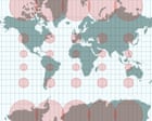
The United Nations has officially integrated the Equal Earth map projection, a decision that marks a significant shift from the long-standing reliance on the 16th-century Mercator model. Three cartographers developed this new projection to rectify the visual distortions inherent in traditional maps, which frequently exaggerated the size of northern hemisphere nations while diminishing the relative scale of Africa and Europe. By providing a more accurate representation of global landmasses, the creators aim to challenge the geopolitical perceptions reinforced by older cartographic standards. Although the transition has been largely successful and widely accepted, the design team noted that a small number of diplomats expressed dissatisfaction with the change. This development highlights ongoing efforts to modernize geographical tools and remove inherent western biases from how the world is visually represented on an international scale.
Source : The Guardian
Photo : The Guardian